|
|
Lake District Mountain and Fell Walks 12Lonscale FellThis is a great walk, encompassing Lonscale Fell. First the route ascends the fell’s placid, rounded south-western slopes to its cairned summit. It then descends the dramatic northern side and finally returns along an old packhorse route half-way up its eastern face. This face forms one side of the great cleft through which flows the lively Glenderaterra Beck. Look up from the parking area, and you can see innumerable walkers climbing the distinct track, first to Skiddaw’s dramatic Little Man and then on along the summit ridge. To the far right of the parking area, looms Blencathra, with its spiky and interesting top. In between is Lonscale Fell and all you can see is a swelling grass and heather mound going on, up and up, receding out of sight. This walk sets out to reveal that there is much more to Lonscale Fell than just a steady upward ascent with no excitements. Go through the gate on the left and walk uphill, with the wall to your left, keeping company with those walkers heading for Skiddaw. Go through the next gate and take the right branch. Continue gently, downhill, into Whit Beck gill. Pause to look upstream at the larches that grow so gracefully about the tumbling water, well out of reach of hungry sheep. Step across and carry on along the continuing track, with fine views opening up across to Blencathra. As you walk on, look down, right, to see Derwentfolds, a pretty, isolated house, set among woodland. At this point look carefully, on the left, to see faint traces of a grassy trod, lined with pale mauve violets in spring, that at first carries on parallel with the track. This insignificant start, which you join, is the fine little path that will take you to the summit of Lonscale.
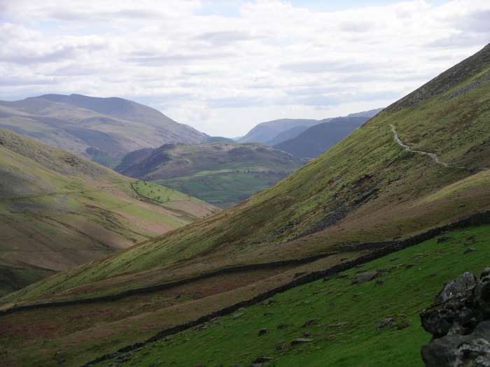
Follow the faint way as it soon turns left and upward, heading towards two paths that you can see ascending the slopes. Suddenly a distinct narrow path emerges. At the Y-junction take the left branch and traverse the slopes, first through grass and then low-growing heather, in the direction of Skiddaw. The way leads to an old gatepost and remnants of fence posts lying on the ground. Here, turn sharp right and carry on up a rising grassy path that passes through banks of heather. Pause often to enjoy the wonderful view below - you might even be able spot people in their kayaks on Derwent Water and the little ferries crossing the lovely lake. Try and name all the many a fells you can spot - this giving you an excuse to get your breath back! See if you can glimpse a tiny patch of blue, the start of Thirlmere. The views from this path are one of Lonscale’s treasures.
On reaching a grassy area, where the heather is left behind, wind round left for a short way and then follow the distinct path straight up, where you guess the summit is just over the brow. Alas there are more of these ‘brows’. Finally the grassy dome is reached and the small but very neat cairn stands near the edge of a great drop. From here you have an extensive view of the northern fells, with Great Calva directly ahead and the Knott just behind it. This is the place for your first stop. Leave the cairn left, west, on a wide grassy swathe with boggy patches on either side, to go through a gate on your right. Follow the fence ahead and then take care as you, and the fence, go down Lonscale’s very, very steep northern side, where there is a path but sometimes it is easier to keep to the thick bank of moss on the right. Pause on a safe place as you go to look back right at the rugged side of the fell. At the foot of the slope, follow the fence as it ascends Burnt Horse on a fine path that runs along the edge of steep craggy slopes and then descends on a long distinct path to a gate on the left, across the Cumbria Way (CW).
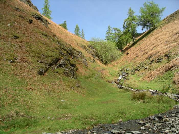
Turn right and carry on ahead on along the CW. This soon comes beside the east face of Lonscale Fell, with steep crags towering sheer above you. The narrow but safe path soon climbs above the steep heather and bilberry slopes dropping to the Glenderaterra Beck far below. Continue on below the Lonscale Crags from where you might hear the piping of a ring ouzel, a white bibbed black bird that lives above the 1000ft contour, replacing the blackbird. Follow the track round below the crags and out into the pastures below the grassy side of the fell once more. Go past the faint start to the path taken earlier and then continue on along your outward route.
Information Start/finish: The lay-by at the end of the narrow road that runs, east, for about a mile from Applethwaite, passing Underscar Hotel. There is space for approximately twenty cars Distance: 10.5 / 6.5 miles Time: 3-4 hours Height gain: 365 m /1191 ft Terrain: Narrow, distinct path most of the way to the summit. Take care down very steep path to CW. The return path, above the Glenderaterra, requires much care if icy. Refreshments: Great choice in Keswick Toilets: Keswick Public transport: None to start. Keswick to Carlisle buses stop at foot of Applethwaite turn off, adding 1.5 miles each way. Walkers may prefer to join CW at Briar Rigg, Keswick, and follow it to start, adding 1.25 mile each way. Park: See above, grid ref 282255 Map: OS Explorer OL 4 Copyright Mary Welsh, © 2008. All rights
reserved. No reproduction without permission. |
|