|
|
Lake District Mountain and Fell Walks 6
Black Combe
Far off, and half revealed, 'mid
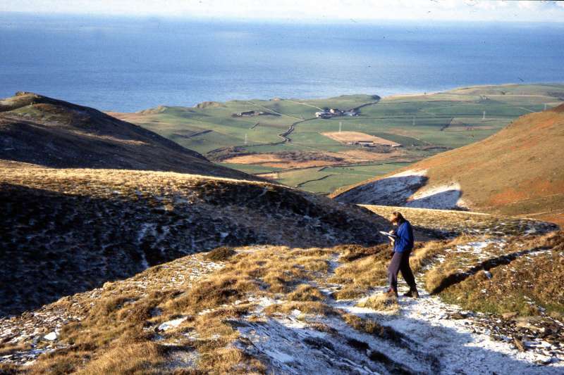
shade and light, So wrote Branwell Bronte, in 1840, when he tutored the sons of Mr Postlethwaite of Broughton House. From here he would have seen the mountain in all its moods. Its moodiness hasn’t changed, so choose a good day for this exhilarating walk. The splendid sprawling giant, 600m/1970 ft high, appears to stand apart from other well known Lakeland heights. And yet this sturdy mountain, its skirts washed by the Irish Sea, lies at the end of a ridge stretching from the mountainous heart of Cumbria. The walk starts from close to the church of St Mary’s in the small village of Whicham, grid ref 136827. It lies on the A595, half-a-mile before it turns sharp right to continue along the west coast. St Mary’s snuggles under Black Combe; it has a bell-cote with two bells, surmounted by a stone cross. It is a plain, simple church, which has been restored several times. Close beside it is the old school, Whicham and Millom Grammar School, which was founded in 1540 and today is divided into cottages.
Park in the layby at the start of the access road to the church or near the church itself. Stroll the walled track that passes between the churchyard and the old school. Turn left to continue along a narrow lane, the access road to Kirkbank farm. Go on along the continuing track, behind the house, and continue to the open fell. Bear right, to climb the slope to pass through the fell gate to join a broad grassy track. And now the climbing begins in earnest. A few yards up, look left to see the Isle of Man stretching like a smoky pointed smudge along the horizon. The path then steepens sharply and becomes rough as you pass through the bracken-clad slopes. By 300m/1000ft the climb has eased and the bracken is replaced by bilberry, heather, moss and lichen. Stride on and on along the pleasing shelf-like track, now with views of the West Cumbrian plain and the mountains of Galloway. Don’t forget to look right to see Walney Island wrapped around the Furness peninsula. Look also for the lagoon at Hodbarrow with Millom close by, its houses huddled around its spired church. Continue on up the good track now 2.5km/1 1/2 miles from the fell gate, until it veers left to wind round below the summit plateau. Here, scramble, right, t up the slope to come to the trig point set in the middle of a drystone shelter - in mist it is possible to be mesmerised by the excellent track and miss the summit altogether! Enjoy the tremendous 360 degrees view. On a clear day, besides seeing the Scottish hills and Snaefell on the Isle of Man, you might just spot the Mountains of Mourne and Snowdon. Nearer at hand Ingleborough stands out solid and clear and the Lakeland panorama is breath-taking. From the summit walk due north, descending a gentler slope to join the track walked earlier after it has curved round Black Combe’s domed top. As you descend you can see the continuing path, which will take you, generally dryshod, across the moorland. Follow the path, which soon becomes a distinct track and goes down in the direction of Bootle, the small village whose market charter was granted in 1347. Look for Barfield Tarn, a circular pool of blue set among green fields. The track divides several times but all paths come down the long gentle slope to unite at the side of a fence. Here bear left, soon to continue beside a wall on your right, beyond which stretch level pastures, with a sparkling blue sea well beyond. The distinct track leads below the wild craggy west face of the mountain, revealing much of its Skiddaw slate bedrock. Step across the hurrying Hallfoss Beck and Holegill Beck and continue on. Pass below Tarn Dimples and then beside a small boarded up cottage. Stride the track, keeping ahead when the wall and a path turn down right. The way soon comes beside the wall on the right again and then go on to Whitbeck Mill, still with its huge but rather sad waterwheel in position. Go behind the mill to look for the pleasing falls in Millergill. Do not return to the continuing track that descends to Whitbeck Church but keep up on the fellside to walk on above the fell wall. Descend banking to cross the beck hurrying down Townend Gill and climb up the other side. Carry on above the fell wall to join a wide renovated track, which steadily ascends the fell ahead of you. Follow this across the slopes and remain with it as it veers left and then descends to the track walked earlier on your climb to the summit. Turn right and descend the steepish track to the fell gate. Beyond bear left to walk the track and then the narrow lane to turn right between the cottages and the churchyard. Information Start/finish: St Mary’s church, in the hamlet of Whicham Terrain: Wainwright described the track to the summit as possible in carpet slippers. Some of the track and the return route should be completed in walking boots. It presents no difficulties, unless the becks are in spate and then some boulder-hopping will be required. Refreshments: Broughton-in-Furness, Millom Copyright Mary Welsh, © 2008. All rights reserved. No reproduction without permission. |
|