|
|
Lake District Mountain and Fell Walks 2
3 Carrock Fell and High PikeCarrock Fell and High Pike Factfile Start/finish: Park on the large verge at
the site of Carrock End Mine, close by Stone Ends, grid ref 354337. (Do
not confuse this with Carrock Mine.) To reach this verge, head north from
Mungrisedale on the fell road and go on through Mosedale. Continue until
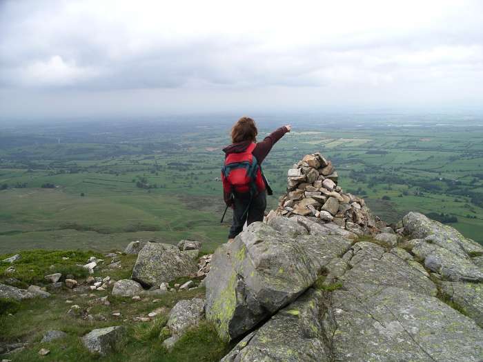
you are below Carrock and park on the left. The steep boulder-littered eastern slopes of Carrock Fell present a striking contrast to massive sprawling High Pike and most of its neighbours, which are grassy, smooth and rounded. Carrock Fell’s elliptical top has two cairns and is surrounded by a collapsed wall with several gaps in it. This is all that remains of an ancient hill fort and the gaps in the wall were probably gates. From the parking area face the fell and look for the old miner’s path slanting left and rising across the lower slopes, now an inviting grassy trod. The easy part over, continue up a stretch of scree and exposed earth, with care, keeping to the right side of the soil. Then cross the scree on a bed of stones and carry on along a grassy traverse. The path soon climbs, right, up a rough stony way, through bracken. Head on up the steepish way to a man-made gully (possibly an old watercourse of a mine) where you can ease your way through by holding on to bracken stems. Climb out of the end of the gully, on the left side, onto the continuing grassy path. Pass through more rocks where many more are hidden by heather and bilberry. Go by a rough stone shelter and then follow an easy path up through boulders to the eastern peak of the fell. Pause here and enjoy the stunning view across the Eden valley. Stride on over the summit, 668 m (2,174 feet) to the large western cairn and enjoy more great views. Descend the north side of this cairn on an indistinct path, through more boulders. Soon you can see the red soil of a track, along which you need to continue, snaking westwards over the extensive, and sometimes, boggy moor. Do not stray from the track as it keeps well to the right of Round Knott and goes on over grassy Miton Hill. Then you reach a cross of grassy trods, Red Gates Track on the OS map. Go over the cross of ways and head on in the same general direction. Climb steadily up beside Drygill Beck, on your right, and then wind round the top of the large gill to reach a reinforced track, which you cross.
Carry on up to the top of High Pike, 658 m (2,157 feet), a short easy climb, and take a well earned rest on the fine seat, with its sad memorial. There is a ruined shelter here, a trig point and a spectacular view. Then make the short descent, north of east, down the easy pathless grassy slope to join the reinforced track crossed a short time earlier. Turn left and stroll on. Look for, but do not visit, some fenced-off shafts of Driggeth mine on your right, and then, just beyond, and still on the right, pass three ancient posts. Here branch right along a grassy track, which soon becomes stony and indistinct. Then move right to edge along the high rim of the mine to your right. There is little to see, but ponder on the conditions under which miners worked on a cold wet winter’s day. Go on down towards Carrock Beck in the valley bottom to join a good miners’ track, which winds left. Stride on below Sunny Bank on your left and then, where the track divides, take the right branch, a pleasing grassy trod, now with the beck just below you. Just after a quarter of a mile, look for a narrow path slanting off from the right side of trod and coming close to a rocky outcrop giving you a fine view of the hurrying beck. The path soon leads into a large area of gorse, but the way is clear and easy to walk and brings you down to a narrow road at the side of a ford. Cross the dancing beck by the footbridge and walk on along the little road. It continues for a short distance as a track and the carries on as the fell road to where you have parked. Copyright Mary Welsh, © 2007. All rights reserved. No reproduction without permission. 4 Steel FellSteel Fell Factfile
The path to the summit cairn is grassy for all but a few steps. The view of Thirlmere overlooked by magnificent Blencathra, especially if covered in snow, is stunning. This walk continues west to Calf Crag, then south-east along the ridge, over Gibson Knott. Just before the wide path up to Helm Crag, a narrow path goes down from Bracken Hause, completing a splendid circular walk. On the way to Steel Fell, (Copyright Mary Welsh, © 2007) Leave the parking area, cross the road and take the footpath, slightly right, across the pasture to Low Mill Bridge, which you go over and bear right. Carry on the quiet lane, past pollarded ash to Ghyll Foot. At the Y-junction take the left branch and climb gently. Pass two cottages on your right and wind round left to go through a gate into the quiet, rarely visited, Greenburn valley.
Follow the way as it approaches the steep slope up onto the summit plateau, ascending the well contoured easy path as it weaves between boulders and the rougher outcrops of Ash Crags. The route, still grassy and distinct, crosses the flattish top to come to the cairn, which is adorned with old fence posts sticking out of the top at various angles. Pause long here to enjoy the fine view.
Just beyond the cairn, a fence comes up the north ridge of Steel Fell, following the old Cumberland and Westmorland county line. The fence then continues, west, along the north rim of Greenburn valley and you take a distinct path that follows the fence. It is easy to walk, mainly grassy, but is bisected by small peaty streams, which you can cross on convenient stones or wind round, always remembering to return to the path. Eventually the fence turns down to the Wythburn Valley and here walkers should go ahead, on a clear path, which follows the line of iron posts that once delineated the county boundary. Sometimes these posts come very near to boggy stretches and over hillocks, but the path always follows the drier, easier way. After a time the posts march straight on and the path veers steadily left, bringing you, with little effort, on to the cairned top of Calf Crag. Perhaps this is the place for a second pause to enjoy another great view. Then carry on along the path, which is much rockier underfoot. It undulates along the ridge, giving delightful views into Far Easedale. After 2.5 km you approach Gibson Knott and can peer into the next dale and see Easdale Tarn. Descend from the Knott to Bracken Hause and, when the steep path up on to Helm Crag lies directly in front of you, look left for a narrow grassy trod through bracken. This drops gently at first and is dry and stony underfoot. Then, where the bracken ends, the grassy slope of this right-of-way drops steeply. Go down carefully to arrive at a huge ladderstile - the wide gaps between the steps makes it difficult for short people to negotiate. Beyond, go on down to reach a Y-junction of grassy trods where a small arrowed pole directs walkers down the left branch to pass through a waymarked gate in the wall. Cross the very narrow end of a pasture to take a gate opposite and carry on down to a footbridge over the tumbling Green Burn. Pause here to enjoy its charming waterfalls and then climb steps and walk right along a track to a gate. Continue on to arrive at the fell gate taken at the outset of the walk. Retrace your outward route. Copyright Mary Welsh, © 2007. All rights reserved. No reproduction without permission. |
|